I edited the page and I didn't experience any particular problems, I'm not sure why you would have been earlier.
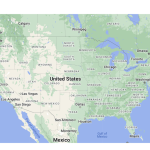
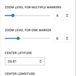
I set the coordinates you specified, and set the zoom at 4 (screenshot).
That fits the contiguous United States into the map boundaries (screenshot).
I checked what it would be like with 5, which wastes less of the space left and right in the oceans, but means that Florida is lost. You would need to make the height of the map larger to fit in Florida at zoom level 5.
Regarding using custom markers, it is a feature that could be implemented with the legacy editors, but is not supported with the newer block-based editor.
In the legacy editor you would add markers to the output of the View using shortcodes (see https://toolset.com/documentation/legacy-features/maps-plugin/displaying-markers-on-maps/). That meant you could combine them with conditional shortcodes so that depending on whether the condition you were testing was met, you could output a marker using a custom icon, and if not output some other icon.
What were you intending to base your custom markers on?
It might be possible to use a hybrid implementation (rather than going all-in on the legacy editor for this page), which keeps the View block you created and jettisons the Map block, implementing the map via shortcodes instead. Do you want to go down that route?
Lastly, sorting is limited to two fields within the UI, the first of which can be any field, the second of which can only be standard fields (e.g. post date) and not custom fields.
But with the API you can use the wpv_filter_query hook to modify the query parameters and set any kind of order conditions you want, but that requires coding: https://toolset.com/documentation/programmer-reference/views-filters/#wpv_filter_query

