Sauter la navigation

[Résolu] Some maps issues

This support ticket is created Il y a 6 années et 6 mois. There's a good chance that you are reading advice that it now obsolete.

This is the technical support forum for Toolset - a suite of plugins for developing WordPress sites without writing PHP.

Everyone can read this forum, but only Toolset clients can post in it. Toolset support works 6 days per week, 19 hours per day.

Sun Mon Tue Wed Thu Fri Sat
- - 14:00 – 20:00 14:00 – 20:00 14:00 – 20:00 14:00 – 20:00 14:00 – 20:00
- - - - - - -

Supporter timezone: Asia/Ho_Chi_Minh (GMT+07:00)

Marqué : ,

Ce sujet contient 7 réponses, a 2 voix.

Dernière mise à jour par Ljuba Il y a 6 années et 6 mois.

Assisté par: Beda.

Auteur
Publications
#950040

Street View not works well and it works well in original Street View. So, issue is that it shows location more than 100m far from actual location. Originally, Street View don't show location as you must first to activate it and than it shows street blue lines where you should to point starting point. That will probably noot be the case if there is also internal Street View of the place, but that is not the case in majority.

Obviously, Toolset tried to do 'workaround' and to "jump" from the pin coordinates "on the street" (as Street View is outside), what was basically mistake as now everything is 'moved' (jumped) arbitrary. My idea was to create another field for Street View (instead to use the same coordinates) as than I can (user can) to control from what point of the street he want to get Street View. Now, there is the problem to programatically set that feature. You can see correctly set and displayed marker on big map "Cerca" and you can see that place have angle of two streets. So, what will be right display??? Obviously is needed another custom field. However, I can't set it as whatever coordinates I place, he shows me the same (and wrong) initial picture (another angle of another street - cca 100m - so, it exists). BTW, Street View on the map not working, as well. You can click indefinitely and it will not open Street View.

Just one additional question - can I disable Google Nearby icons (is it there some option)?

#950058
Add default Street View to the map.png

I am not sure to understand.

1. If a Street View exist, and you select to load StreetV new by default, then that works.
I tested this

2. If the street view does not exist, Maps fall back to satellite.

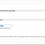
I added a ScreenShot of the setting in the GUI I used and a copy of my ShortCodes

<!–– Render the First Map, here we load Street View by Default, using the current marker, on a single post ––>
[wpv-map-render map_id="map-1" street_view="on" marker_id="street-view"][/wpv-map-render]
[wpv-map-marker map_id='map-1' marker_id='street-view' marker_field='wpcf-ddress'][/wpv-map-marker]

<!–– Render the Second Map, here we DO NOT load Street View by Default but keep it activable so to compare the viewed things. We are using the current marker, on a single post, again, but will scroll in and drop the StreetView Icon on the marker so to compare it with above output of Map #1 ––>
[wpv-map-render map_id="map-2" ][/wpv-map-render]
[wpv-map-marker map_id='map-2' marker_id='marker-2' marker_field='wpcf-ddress'][/wpv-map-marker]

3. If this issue persist as you describe after updating Toolset and not using other Software, please can you describe the exact steps you take to replicate this?

#950466
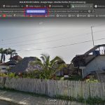
004.jpg
003.jpg
002.jpg
001.jpg

I will try best to explain. Unfortunately, my animated GIF is 4.8MB, but I will try with images.

1) Beckend is lien caché

2) Front page is lien caché

3) Used Content Template is at lien caché with code

[wpv-map-render map_id="map-1" street_view="on" marker_id="street-view"][/wpv-map-render]
[wpv-map-marker map_id='map-1' marker_id='street-view' marker_field='wpcf-ubicacion-del-negocio'][/wpv-map-marker]

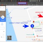
4) Image 001 shows you official Google Map marker point (red rectangle in browser bar and point is used in beckend of the site). Logically, marker is within lot space (green square). Google link is lien caché.

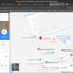
5) As Street View is on the street and when you click on Street View icon, it shows you blue street lines to choose street point for view (image 004). Street View will not act like this ONLY if exists internal Street View with the same point of object marker (what is mainly not the case in Ecuador).

6) At image 001 you see blue circle as correct marker for street view and if on image 004 you point it on blue street lines, you will get Street View as on image 002 (correct view).

7) Image 002 also show in red navigation bar rectangle, coordinates for those Street View marker (logically different from property location marker - as point is on the street).

8) Image 003 shows you Street View what you get from Toolset Maps WHATEVER MARKER COORDINATES YOU PLACE IN BACKEND and shows you in red rectangle real coordinates. That point position of the marker is visible as RED CIRCLE on image 001 (around 50-100m far from property - depends from where you start to measure).

9) So, real property marker is at -0.4616849,-80.4578197. Correct street view marker should be at -0.4617322,-80.457378 (I can make another field for Street View). Toolset displayed marker is at -0.4614496,-80.457118 in both cases (try to change locations in backend with first two and you will get same view in both cases).

CONCLUSIONS

A) Google correctly shows EVERYTHING (see images).

B) I can add additional field for Street View location, but .... useless as Toolset shows same for both coordinates.

MYSTERY (and solution)

How possibly Toolset Maps can shows Street View automatically when Google itself cannot to do it, as previously must to ask you to point the marker on the street (see blue street lines on 004)???

Consequence of Toolset Maps arbitrary 'automatic' algorithm is that Toolset shows arbitrary Street View point and I don't have idea how to solve that.

#952128

Sorry, but if I save -0.4616849,-80.4578197, in the backend address field, and load Street View by default in the map, it does load Street View as that does exist there it seems, and it shows the marker at the exact same location on the backend or front end - it does not matter, and as well the street view is correctly set.

This, is tested on a local fresh install with the latest Toolset.
I do not know where you click to activate a street view as there is no such thing to do in the map, you could maximally drag the little "man" icon that activates the street view, but not click it.

This is how you can prove that the Map shows the street view and marker just fine:
1. Create an address field
2. Save this for a post:
-0.4616849,-80.4578197
3. Display it as:

[wpv-map-render map_id="map-2" street_view="on" marker_id="street-view-unique"][/wpv-map-render]
[wpv-map-marker map_id='map-2' marker_id='marker-2' marker_field='wpcf-addresss'][/wpv-map-marker]
[wpv-map-marker map_id='map-2' marker_id='street-view-unique' marker_field='wpcf-addresss'][/wpv-map-marker]

This will show a street view loaded mat at first, where the marker is at the exact defined point /address.

This, does not work on your site, I tested it.

This is in fact because that post has this Long Lat:
{-0.4617322,-80.457378}

While in the post above you told me to use {-0.4616849,-80.4578197}

When I use -0.4616849,-80.4578197 on my, or your site, it works.
When I use {-0.4616849,-80.4578197} it breaks.

I believe, I confirmed thus on your install the same, can you confirm this as well?
I escalated this bug 🙂

Is there any other disfunction I did not yet get?

Thanks Ljuba, we have considerable work until I understand you, but we also fix many issues with your help, and I appreciate that.

I hope my help is of value to you as well, otherwise please do not hesitate to let me know.
BTW, I speak as well Spanish, I am not sure if you are more into that language?
#952165

1) "I believe, I confirmed thus on your install the same, can you confirm this as well?"

Yes, I confirm. YOU LOCATED THE BUG

2) "Is there any other disfunction I did not yet get?"

Yes, but probably is some my fault and not the issue of Toolset. I just need reply/confirmation/correction....

a) You can see at lien caché on street view map how it shows the street. Is it the way to set it initially rotated to the building (instead to street)? So, full Street View rotated address is -0.4617322,-80.457378,3a,75y,67.16h (angles), but such address is not supported by Toolset.

3) " hope my help is of value to you as well, otherwise please do not hesitate to let me know.
BTW, I speak as well Spanish, I am not sure if you are more into that language?
"

==> I actually enjoy to work with you, Nigel and Christian. So, three of you, seriously helped me a lot to figure (at least something of) this Toolset. BTW, I have also WPML developer license, but I never needed any kind of help.

==> I'm positive that you didn't forgot how I already answered on your remark about Spanish (and probably you didn't get me well). I'm Croat left long time ago (with 7 years) from Yugoslavia and who lived in many countries. So, I learned about 14 languages (and I still can use it all of them), but ANY OF THEM I speak well (including Spanish and English). I'm living here in Ecuador over 10 years, but this technical terms are certainly better for me in English. 'Everyday vocabulary' is certainly better Spanish.

==> Once (very long time ago) I created something like this at lien caché ..... but that is the forgotten history. BTW, I'm the Linux (Arch and Fedora) user.

==> It is my pleasure to know you guys.

#952183

1. Is it the way to set it initially rotated to the building (instead to street)? So, full Street View rotated address is -0.4617322,-80.457378,3a,75y,67.16h (angles), but such address is not supported by Toolset.

We definitely do not support such needed syntax.
I can add this as a feature request.

2. Great, let's then go on in English, It's as well easier for me (technical terms)

I am happy we can help you - and I do hope Toolset becomes less and less unintuitive with the time.

#952202

OK

We can close topic.

I think that Toolset need to do that, as there is no some systematic sense to use Street View with unknown position vs rotation. So, if final user (member) cannot set View to his own building, he certainly don't want such map view (with view on street). In other words, I cannot see how possibly I can use it (or anybody). I repeat, it probably works well when there is internal Street View, but in non developed countries that is certainly not the case.

#952203

Thanks for help and found BUG.